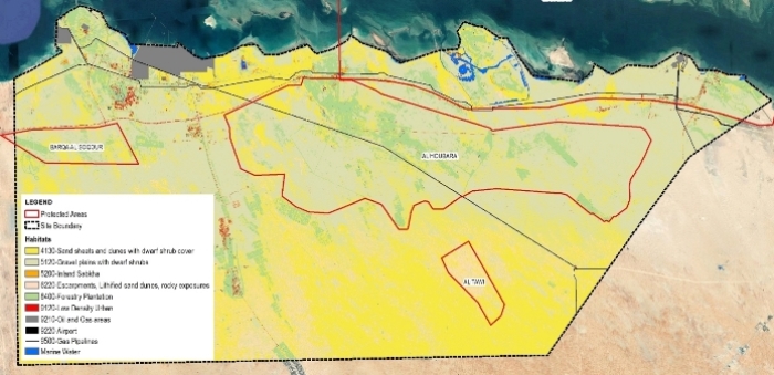
Al Ruwais Seismic Survey Habitat Mapping – Abu Dhabi

The scope of our services is to provide GIS services to the client in preparing habitat maps of 4,100 sq km area in the Emirates of Abu Dhabi. This habitat map is prepared as per EAD standards required for NOCs approval from Environmental Agency. We have used high resolution multiband imagery (Freeware) for classification and habitats identification.

General Engineering Services For Local Roads & Drainage – Qatar

CAD to GIS Conversion *** Technical involvement in the development of GIS database for Concept Design, Detail Design and As-Build drawings for roads, electrical & street lighting, telecom, potable water, storm water, sewer and TSE for Asghal (the client). Convert all drawings from AutoCAD to GIS within ESRI environment. Technical support (GIS) to geotechnical and environment teams in obtaining NOCs from Environment Protection Agency (EPA) Qatar.

Desert Rose Smart City – Dubai

The scope of our services is to provide GIS services to the client to prepare habitat mapping and GIS datasets (shape files) required for NOCs from Environmental Agency for approvals. We also support our client in procuring high resolution multi-band satellite imagery to produce habitat maps using classification and ground verification methods.

Dubai EXPO Link Project – Dubai

The scope of our services is to provide GIS services to the client in preparing GIS plans for environmental monitoring location (Air Quality, Noise and Vibration) using KMZ and Satellite Imagery. We have converted all data from different sources to DLTM coordinate system (Dubai Local System) to meet the standards set by Environmental Agency for further approvals.

Habitat Mapping, Yas Island Zone 1B – Abu Dhabi

The scope of our services is to provide GIS services to the client in preparing habitat maps and and GIS datasets (shape files) required for NOCs from Environmental Agency for approvals. Along-with the analysis we also support our client in procuring high resolution multi-band satellite imagery and produce habitat maps using classification and ground verification methods.